- How vulnerable are Australia’s cities to extreme heat? Explore our new maps!
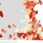 Extreme heat is one of Australia’s most dangerous natural hazards and it’s getting worse. Our new national data reveals which neighbourhoods across Australia are most at risk and why.
 - Harnessing Data to Drive Liveability
 In an era where urbanisation is rapidly transforming our cities, the need for sustainable, liveable, and healthier communities has never… Read more: Harnessing Data to Drive Liveability
 - Swim Melbourne | Places to Swim Across the City
 Swim Melbourne provides a map of places to swim across the city, useful information about safety and water quality, as well as stories of urban swimming in pools, the Yarra and Port Phillip Bay.